Showing 37 items matching electoral maps
-
 Melbourne Tram Museum
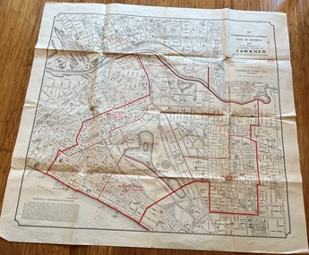
Map, Department of Lands and Survey Melbourne, Commonwealth Electoral Division of Fawkner, 1-10-1912
... Electoral maps...Folded sheet - Map - Commonwealth Electoral Division.... Melbourne Fawkner tram lines cable trams maps Electoral maps South ...Shows a detailed street plan of South Melbourne, Albert Park, Prahran, South Yarra and parts of Melbourne in 1912. Used to mark the electoral boundaries of the Commonwealth Electoral Division of Fawkner. Shows all the then cable tram lines, rail lines and the electric line of the PMTT along with docks, gardens and significant buildings.Gives details of the Fawkner Electoral district in 1912.Folded sheet - Map - Commonwealth Electoral Division of Fawkner - two colours showing the subdivisions and polling placesmelbourne, fawkner, tram lines, cable trams, maps, electoral maps, south melbourne, albert park, prahran -
 Whitehorse Historical Society Inc.
Map, State Electoral Map, 1926
... State Electoral Map...State Electoral Map: Metropolitan and country areas... Mitcham melbourne Map Map State Electoral Map State Electoral Map ...State Electoral Map for 1926.State Electoral Map: Metropolitan and country areas, showing changes to electoral districts legislated in the Redistribution of Seats Bill 1926State Electoral Map for 1926.victoria, electoral boundaries -
Stawell Historical Society Inc
Map - Electoral Map, Victorian Government, Map of North - Western ( Country) Electoral Province Legislative Council 1934, 1939
... Electoral Map...Electoral Map... grampians Electoral Map Map Map of North - Western ( Country ...Electoral MapMap Overprinted with Provinces In RedScale 8 Miles to 1 Inchgovernment -
Stawell Historical Society Inc
Map - Electoral Map, Federal Government, map of Commonwealth Electoral Division of Wimmera 1949, 1949
... Electoral Map...map of Commonwealth Electoral Division of Wimmera 1949...Electoral Map...Map overprinted with Electoral Divisions in Red... grampians Electoral Map Map map of Commonwealth Electoral Division ...Electoral MapMap overprinted with Electoral Divisions in Red. Description of Division of Wimmera Scale in Miles. Commonwealth of Australia State of Victoriagovernment -
Stawell Historical Society Inc
Map - Electoral Map, Local Government, Local Government Boundry Status as at 31st January 1995, 1995
... Electoral Map...Electoral map... grampians Electoral Map Map Local Government Boundry Status ...Electoral mapTwo (2) Maps Overprinted in Red Showing Local Government Boundries for State and port Phillip AreaSheet 1 of 2 Sheet 2 of 2government -
 Greensborough Historical Society
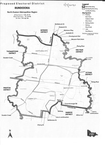
Map - Map (Copy), Electoral Boundaries Commission, Proposed electoral district: Bundoora, 01/07/2021
... Plenty Lower Plenty melbourne Map (Copy) Map Proposed electoral ...Proposed revised electoral boundaries for the electoral district of Bundoora (North-Eastern Metropolitan Region) as at 01/07/20211p. black and white copy of mapelectoral boundaries, bundoora - maps, victoria - parliament -
Ballarat Tramway Museum
Map, Ballarat Litho & Printing Co, "Electoral Map of Ballarat", 1920's?
... "Electoral Map of Ballarat"...Map showing the electoral boundaries of Ballarat - State... Parade Ballarat Ballarat goldfields Map "Electoral Map ...Map showing the electoral boundaries of Ballarat - State? - possibly early 1920's. Has been marked up in blue pencil for electric and horse tram routes around Ballarat, along with names of terminals, depot, and other points of interest. Shows horse trams lines in Macarthur St and Armstrong St. Also has in pencil, approximate location of the railway to Buninyong. Map shows location of Showgrounds (old location), Hospital for epileptics, abattoirs, but does not show Ballarat North Railway Workshops. Title Block "Ballarat Litho & Ptg. Cos. / Electoral Map of / Ballarat / Scale 20 chains to One Inch" To be stored with minimal folding.trams, tramways, map, ballarat, horse trams -
Glen Eira Historical Society
Book - GLEN EIRA GUIDE
... and state electoral maps. The second section, titled Council... management, and federal and state electoral maps. The second section ...This file contains one item: 1/A copy of the 1999 edition of the Glen Eira guide. This magazine aims to provide readers with useful information for living and working within the City of Glen Eira. It is divided into five principal sections. The first section, titled Glen Eira City Council Information, provides information pertaining to the local government. It includes information about Council meetings, the names and contact details of the six members of the Council, information about services offered by the Glen Eira Service Centre, the contact details for particular services offered by the Glen Eira City Council, information about rates and valuations, information about the building permit application process, information about waste management, and federal and state electoral maps. The second section, titled Council and Community Resource Guide, consists of a list of the various local community facilities and organizations. The third section, titled City of Glen Eira Safe Food Guide, consists of a list of food venues nominated by the Glen Eira City Council Environmental Health Services Department for their commendable level of hygiene. The fourth section, titled City of Glen Eira Business Development Unit, provides information about the eponymous local government department, which is aimed at providing aid to local businesses. The fifth and final section, titled ‘Think Local, BUY LOCAL’ Guide, consists of a list of local businesses, grouped according to industry, to try and encourage the support thereof.glen eira, city of glen eira, glen eira city council, local government, local officials and employees, kennedy norman cr, mayors, public utilities, community services, local government departments, rates, local government, building permits, waste disposal, community groups, cultural structures and establishments, law and order, libraries, education, educational and research establishments, religious groups, clubs and associations, community centres, food, restaurants, businesses -
 Greensborough Historical Society
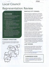
Document - Document Collection, Local Council Representation Review, 2019_
Contents: 2 x Newspaper Clippings: Banyule City Council Electoral Representative Review, Heidelberg Leader 20/08/2019 and Diamond Valley Leader 21/08/2019. Local Council Representative Review Submission Guide. Victorian Electoral Commission, 2019. 24 p., text. General information for those making a submission to a review. Local Council Representative Review Preliminary Report: Banyule City Council. Victorian Electoral Commission, August 2019. 31 p., text and colour maps. Reports on submissions and gives 3 options for electoral review in Banyule. Local Council Representative Review: Banyule City Council 1. Public hearing agenda and attachments. 25/09/2019. 9 p. 2. Public hearing agenda and attachments. 25/09/2019. 2 p. Agenda and handwritten notes by R. Bray. Local Council Representative Review Final Report: Banyule City Council. Victorian Electoral Commission, October 2019. 46 p., text and colour map. Recommends increasing the number of councillors and wards to 9. 2 newspaper clippings, 3 booklets and agenda with attachments. Filed in black plastic folder.banyule city council, victorian electoral commission, local council representative review 2019 -
 Greensborough Historical Society
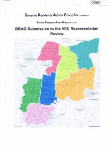
Document, BRAG submission to the VEC Representation Review, by Banyule Residents Action Group Inc, 2019_
This is a submission to the Victorian Electoral Commission, which periodically reviews electoral representation in municipal areas. The last review of Banyule City Council was in 2007.7 p. typescript with colour mapbanyule city council, brag banyule residents action group -
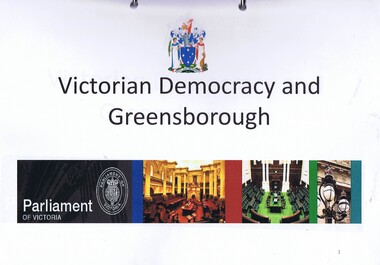 Greensborough Historical Society
Folder, Victorian democracy and Greensborough, compiled by Anne Paul, 2019_06
Outline of events leading to independent separate representative government for Victoria in 1850, and information on electoral districts and parliamentary members in the Greensborough and surrounding areas to date. Talk presented by Anne Paul to a GHS General meeting on 29 June 2019.90 p. in loose leaf ring binder. Text, maps and colour illustrations. Printed copy of PowerPoint presentationgreensborough, victoria parliament, anne paul -
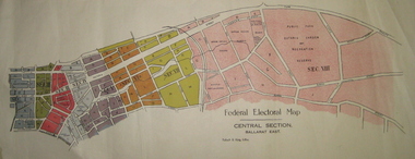 Federation University Historical Collection
Plan - Plans, Tulloch & King, Federal Electoral Map Subdivision of Ballarat, c1901
... Federal Electoral Map Subdivision of Ballarat...electoral map... Plan Federal Electoral Map Subdivision of Ballarat May ...It is thought that these are the first federal electorial plans for the Subdivision of Ballarat. The first member of Ballarat was Alfred Deakin.May of the Federal subdivision of Ballarat, with each section depicted in a different colour. The plans include Lake Wendouree, Central Ballarat subdivision; Soldiers Hill subdivision; Ballarat East subdivision, and Central Section Ballarat East, including the Ballarat East Botanic Garden .ballarat, federation, alfred deakin, elections, plan, electoral division, electoral map, polling -
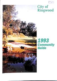 Ringwood and District Historical Society
Book, City of Ringwood, City of Ringwood 1993 Community Guide, 1993
... Design and Investigation 23 Works 24 Street Index - Electoral... Design and Investigation 23 Works 24 Street Index - Electoral ...Community information book issued by City of Ringwood for 1993 - covering the facilities and activities of the Ringwood Council and other local organisations and associations. Includes two Ringwood Aquatic Centre bonus entry vouchers valid until June 30th, 1993. Cover photographs: Front - Poppet Head, Ringwood Lake; Back - Opening of North Ringwood Child Care Centre. CONTENTS: (page no.) Message from the Mayor – Cr. Greg Adkins, J.P. 3 Councillors 4 Council & Committee Cycle 5 Council Elections 6 History of Ringwood 7 Chief Executive's Report 8 The Management Team 9 Functional Responsibilities 10 Community Liaison 11 Council Expenditure for 1992/93 12 Rates and Valuations 13 COUNCIL SERVICES Community Services 14 Protecting the Environment 17 Protecting Our Community 19 Town Planning 21 Building 22 Design and Investigation 23 Works 24 Street Index - Electoral Wards 25 Neighbourhood Map 26 and 27 COUNCIL RECREAION AND LEISURE FACILITIES Ringwood Golf Course 29 Aquatic Centre 30 The Ringwood Convention Centre 32 Ringwood Library 34 Ringwood Recreation 35 Parks and Reserves 30 Community Directory 38-50 Community Information Data Bank 51 Aquatic Centre Vouchers 51rinx -
Kew Historical Society Inc
Administrative record, City of Kew, City of Kew Voters Roll 1986-1987 Central Ward, 1986-1987
non-fictionlocal government -- electoral rolls -- kew (vic) -
Kew Historical Society Inc
Administrative record, City of Kew, City of Kew Voters Roll 1986-1987 College Ward, 1986-1987
non-fictionlocal government -- electoral rolls -- kew (vic) -
Kew Historical Society Inc
Administrative record, City of Kew, City of Kew Voters Roll 1986-1987 North Ward, 1986-1987
non-fictionlocal government -- electoral rolls -- kew (vic) -
Kew Historical Society Inc
Administrative record, City of Kew, City of Kew Voters Roll 1986-1987 Studley Park Roll, 1986-1987
non-fictionlocal government -- electoral rolls -- kew (vic) -
Kew Historical Society Inc
Administrative record, City of Kew, City of Kew Voters Roll 1990-1991 Prospect Ward, 1990-1991
non-fictionlocal government -- electoral rolls -- kew (vic) -
Kew Historical Society Inc
Administrative record, City of Kew, City of Kew Voters Roll 1990-1991 Studley Park Ward, 1990-1991
non-fictionlocal government -- electoral rolls -- kew (vic) -
Kew Historical Society Inc
Administrative record, City of Kew, City of Kew Voters Roll 1990-1991 Willsmere Ward, 1990-1991
non-fictionlocal government -- electoral rolls -- kew (vic) -
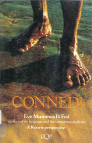 Victorian Aboriginal Corporation for Languages
Book, Eve Mumewa D Fesl, Conned!, 1993
Language is power. It is used to describe and direct events fictional and true. This book describes how historians have manufactured a flattering Australian race relations history. Conned! challenges established perceptions of Indigenous Australians.maps, b&w illustrations, b&w photographs, chartsaboriginal languages association, atsic, education, electoral system, moravian -
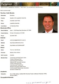 Greensborough Historical Society
Document, Parliament of Victoria, Ministers & Members search - the Hon. Colin Brooks (Bundoora), 23/04/2021
... website; and, map of the electoral district of Bundoora....2 p. text and colour photograph, with colour map... and colour photograph, with colour map of Bundoora Electoral District ...Biographical details of the Hon. Colin Brooks, MLA for Bundoora, taken from Parliament of Victoria - Ministers and Members website; and, map of the electoral district of Bundoora.2 p. text and colour photograph, with colour map of Bundoora Electoral Districtbrooks family, victoria parliament, colin brooks, bundoora -
 Eltham District Historical Society Inc
Document - Folder, Eltham Shire: Guide to historical sources held in the LaTrobe and Reference Library Collections, State Library of Victoria, 1980
Two copies. Folders 68 and 74 from Harry Gilham Collection. "The following work was undertaken at the request of the Shire Planner of the Shire of Eltham to aid in the establishment of a total inforamtion system for the Shire. It is primarily a guide to sources of historical information on the area within the present shire boundaries and also the additional areas which were within the shire's former boundaries". Sources are arranged in the following sections: bibliographies, books and pamphlets, serials, electoral rolls, directories, statistical material, maps, pictorial material and manuscripts.12 pages in a manilla folderWithdrawn copy from Yarra Plenty Regional Librarybibliography, library -
Port Melbourne Historical & Preservation Society
Document - Voters Rolls, District of Sandridge
Five (5) municipal electoral rolls(photocopies), District of Sandridge 1861; 1862; 1863; 1865; 1866 Photocopy of 1860 map, catalogue no 2083local government - borough of sandridge -
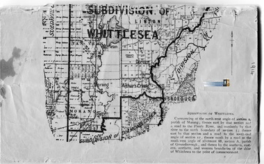 Whittlesea Historical Society Inc.
Booklet - Electoral Roll, Commonwealth of Australia. State of Victoria. Division of Corio. Roll of Electors for the Subdivision of Whittlesea, 1914
Paper, typed document, staples along spine, some loose pages, very fragile, 19 p., map.Alphabetical list of names including residence and occupation of Electors for Subdivision of Whittlesea. Dated 1914. By Authority: Albert J. Mullet Government Printer for the State of Victoria.whittlesea, roll of electors, yan yean, morang, doreen, arthurs creek, linton -
Whitehorse Historical Society Inc.
Map, Aston, 1989
... Map of the Commonwealth Electoral Division of Aston. Scale... Mitcham melbourne Map Map Aston Map of the Commonwealth Electoral ...Map of the Commonwealth Electoral Division of Aston. Scale 1:25,000Map of the Commonwealth Electoral Division of Aston. Scale 1:25,000Map of the Commonwealth Electoral Division of Aston. Scale 1:25,000electoral boundaries, aston (commonwealth electoral division) -
Whitehorse Historical Society Inc.
Map, Bruce, 1989
... Map of the Commonwealth Electoral Division of Bruce... Mitcham melbourne Map Map Bruce Map of the Commonwealth Electoral ...Map of the Commonwealth Electoral Division of BruceMap of the Commonwealth Electoral Division of BruceMap of the Commonwealth Electoral Division of Bruceelectoral boundaries, bruce (commonwealth electoral division) -
Whitehorse Historical Society Inc.
Map, Chisholm, 1989
... Map of the Commonwealth Electoral Division of Chisholm... chisholm (commonwealth electoral division) Map of the Commonwealth ...Map of the Commonwealth Electoral Division of Chisholm. Scale 1:25,000.Map of the Commonwealth Electoral Division of Chisholm. Scale 1:25,000.Map of the Commonwealth Electoral Division of Chisholm. Scale 1:25,000.electoral boundaries, chisholm (commonwealth electoral division) -
Whitehorse Historical Society Inc.
Map, Deakin, 1989
... Map of the Commonwealth Electoral Division of Deakin. Scale... Mitcham melbourne Map Map Deakin Map of the Commonwealth Electoral ...Map of the Commonwealth Electoral Division of Deakin. Scale 1:25000.Map of the Commonwealth Electoral Division of Deakin. Scale 1:25000.Map of the Commonwealth Electoral Division of Deakin. Scale 1:25000.electoral boundaries, deakin (commonwealth electoral division) -
Whitehorse Historical Society Inc.
Map, Deakin, 1977
... Map of the Commonwealth Electoral Division of Deakin... Mitcham melbourne Map Map Deakin Map of the Commonwealth Electoral ...Map of the Commonwealth Electoral Division of Deakin. Scale 1: 25,000.Map of the Commonwealth Electoral Division of Deakin. Scale 1: 25,000.Map of the Commonwealth Electoral Division of Deakin. Scale 1: 25,000.electoral boundaries, deakin (commonwealth electoral division), australia. parliament